How Deep Are Quarries and What Makes Them So Massive
When you think about quarries, you might picture a simple hole in the ground. But these excavation sites can reach staggering depths that would surprise you. The deepest quarries in the world plunge over 1,200 meters below the surface, with some like Utah’s Bingham Canyon Mine being so massive they’re visible from space.
Understanding quarry depths helps us appreciate the incredible engineering behind extracting the materials that build our roads, homes, and infrastructure. From limestone quarries that powered ancient pyramid construction to modern copper mines feeding global industry, these excavations represent some of humanity’s most ambitious earth-moving projects.
Quick fact: The world’s deepest open-pit mine, Bingham Canyon, measures 1.2 kilometers deep and 4 kilometers wide, making it one of the largest man-made excavations on Earth.
What determines how deep quarries go
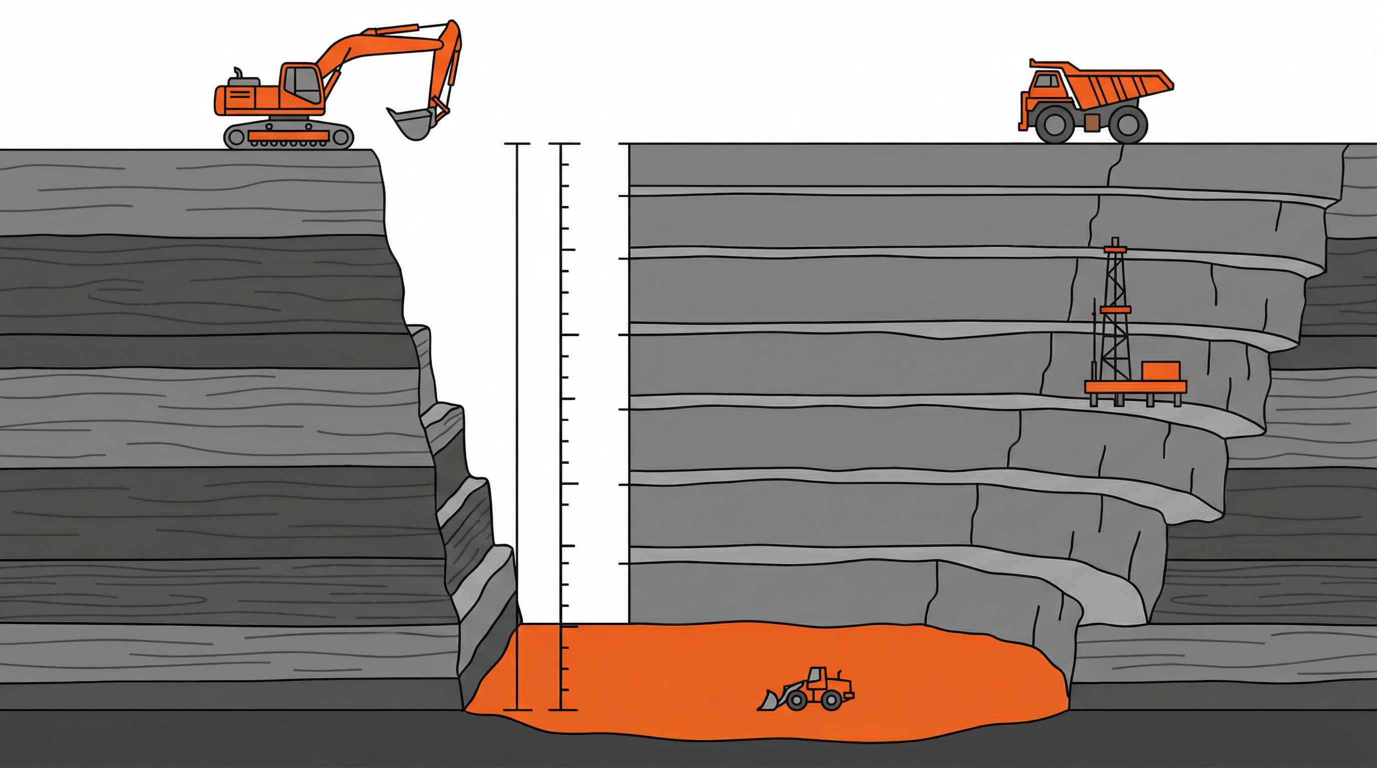
The depth of any quarry depends on where valuable materials sit underground and how much companies need to extract. Think of it like digging for buried treasure – you go as deep as necessary to reach what you’re after.
Geological factors play the biggest role. If limestone deposits extend 500 meters down, that’s how deep the quarry needs to go. Harder rock formations like granite might require different extraction approaches that influence the final depth. The surrounding bedrock composition also matters – softer materials allow for wider, shallower quarries, while harder formations often result in deeper, narrower excavations.
Technology and economics create practical limits. Modern equipment can reach impressive depths, but costs increase dramatically the deeper you go. Companies balance extraction expenses against material value to determine optimal depth. Advanced techniques like diamond wire sawing and precision blasting now allow access to previously unreachable deposits, similar to how modern quarrying processes have evolved over time.
How quarry depths get measured accurately
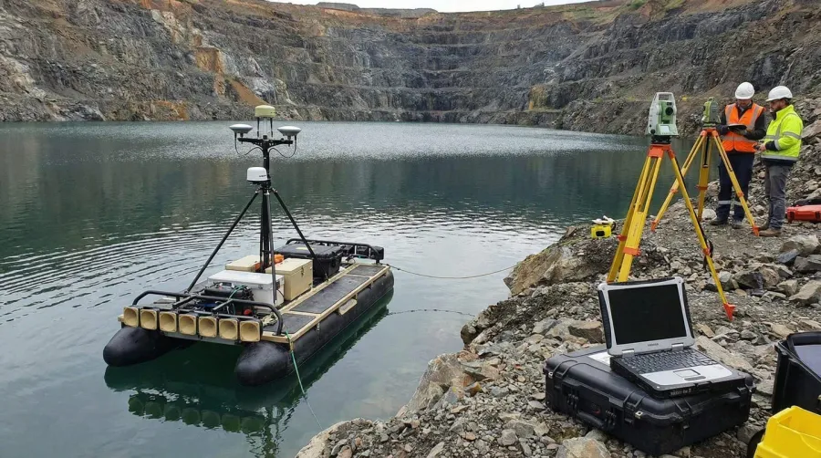
Measuring quarry depth requires specialized techniques because traditional methods don’t work in these massive excavations. You can’t simply drop a measuring tape into a 1,000-meter pit and expect accurate results.
Sonar technology works best for water-filled quarries. Equipment mounted on boats or surface vehicles sends sound waves to the bottom, measuring travel time to calculate depth. This method provides reliable measurements even in the deepest sections where direct access proves impossible.
GPS and laser surveying handle dry quarries through precise surface mapping. Surveyors establish reference points around the quarry rim, then use advanced equipment to map the entire excavation. Drilling boreholes offers another approach, particularly useful for determining bedrock depth and planning future expansion.
Measurement challenge: GPS signals can’t penetrate solid rock, making underground depth measurement one of the most technically demanding aspects of quarry operations.
The biggest measurement challenges come from accessing remote areas within deep quarries. Safety regulations often prevent direct human access to the deepest sections, requiring remote measurement techniques. Weather conditions, dust, and equipment limitations can also affect measurement accuracy.
The world’s most impressive deep quarries
Several quarries around the globe showcase the incredible depths humans can achieve when extracting earth’s resources. These sites represent engineering marvels that supply essential materials for global construction and manufacturing.
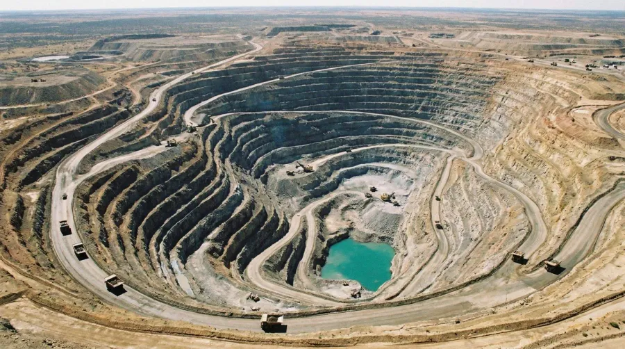
According to heidelbergmaterials.my, the Bingham Canyon Mine in Utah stands as the world’s deepest open-pit operation at over 1,200 meters deep. This copper mine has operated since 2026 and produces copper, gold, and silver for global markets. Its massive scale – 2.5 miles wide and half a mile deep – makes it visible from space.
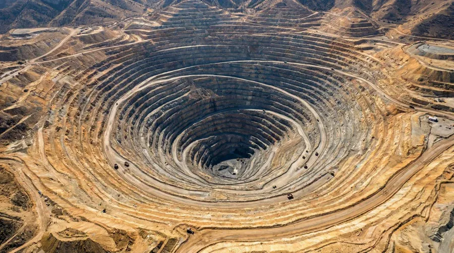
Chile’s Chuquicamata copper mine reaches 850 meters deep and has extracted copper for over a century. Owned by Codelco, this operation may transition to underground mining as surface deposits become harder to reach economically.
Russia’s Udachny diamond mine in Siberia extends 630 meters down and once produced 10 million carats annually. The whiteclouds.com source notes that this ALROSA-owned facility significantly contributed to global diamond supplies during its peak production years.
| Quarry Name | Depth (meters) | Location | Primary Material |
|---|---|---|---|
| Bingham Canyon | 1,200+ | Utah, USA | Copper, Gold, Silver |
| Chuquicamata | 850 | Chile | Copper |
| Udachny | 630 | Russia | Diamonds |
| Fimiston Super Pit | 600 | Australia | Gold |
Environmental considerations for deep excavations
Deep quarries create significant environmental impacts that extend far beyond their physical boundaries. Understanding these effects helps communities and companies work together on sustainable extraction practices.
Groundwater disruption represents one of the most serious concerns. When quarries remove massive amounts of bedrock, they can alter underground water flow patterns. This affects local wells, springs, and surface water bodies that depend on consistent groundwater supply. Changes in water quality and quantity can impact entire ecosystems downstream.
Habitat destruction occurs when large land areas get cleared for quarry operations. The hellogravel.com research shows that this clearing affects local wildlife populations and can fragment migration routes. Deep excavations also create permanent landscape changes that require careful rehabilitation planning.
Environmental impact: Modern quarries implement restoration programs that can transform former excavation sites into valuable community resources like parks, lakes, and wildlife habitats.
Erosion and sedimentation affect nearby water systems when quarry operations expose large soil and rock surfaces. Heavy rainfall can wash loose materials into streams and rivers, affecting aquatic life and potentially causing flooding issues. Many operations now use advanced drainage systems and sediment control measures to minimize these impacts, similar to how gravel is used in drainage systems for erosion control.
The good news is that many quarries successfully transform into beneficial community resources after extraction ends. Former quarry sites become recreational lakes, nature preserves, and even residential developments. The en.wikipedia.org example of Thornton Quarry shows how these sites can serve new purposes – this Illinois quarry now functions as a massive stormwater reservoir protecting surrounding communities from flooding.
Understanding quarry depths helps us appreciate both the engineering achievements and environmental responsibilities involved in extracting the materials that build our modern world. From ancient limestone quarries to today’s high-tech operations, these excavations continue evolving to meet growing material demands while minimizing environmental impact through sustainable quarrying practices.
FAQ
How deep are quarries typically?
Quarries typically range from 10 to 500 meters deep, depending on the type of material being extracted and geological conditions. Limestone and gravel quarries often reach 30-100 feet (10-30 meters), while hard rock granite quarries can exceed 500 meters. The depth is determined by where valuable materials sit underground and how much companies need to extract economically.
What is the deepest quarry in the world?
The Bingham Canyon Mine in Utah, USA is the world’s deepest open-pit excavation at over 1,200 meters (0.75 miles) deep and 4 kilometers wide. While technically a copper mine rather than a traditional stone quarry, it represents the deepest man-made excavation on Earth and is so massive it’s visible from space.
How do surveyors measure quarry depth accurately?
Quarry depth measurement uses specialized techniques including sonar bathymetry for water-filled quarries, GPS and laser surveying for dry quarries, and drilling boreholes to determine bedrock depth. Sonar technology works by sending sound waves to the bottom and measuring travel time, while GPS systems map the entire excavation from surface reference points. These methods are necessary because traditional measuring techniques don’t work in massive excavations.
What environmental impacts do deep quarries create?
Deep quarries create significant environmental impacts including groundwater disruption that can alter underground water flow patterns affecting local wells and springs, habitat destruction when large land areas are cleared, and erosion and sedimentation that affects nearby water systems. However, many quarries successfully transform into beneficial community resources after extraction ends, becoming recreational lakes, nature preserves, or even stormwater management facilities.